


Latest Video
News
-

Meteo Curacao uploaded a video (7/5/2024)
Meteorological Department Curaçao
-
Meteo Curacao uploaded a video (7/1/2024)
Beryl Yuli 2024
-

-
Meteo Curacao uploaded a video (5/13/2024)
Meteorological Department Curaçao
-
Meteo Curacao uploaded a video (11/20/2023)
Boletin semanal 20 Nov te ku 26 Nov 2023
Weather Warning
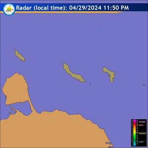
Radar
Satellite (InfraRed)

Forecast
Weather Forecast for Curaçao and surroundings valid until Wednesday morning
06:00 l.t., July 21, 2026.
Issued:
Tuesday July 21, 2026, 05:00 l.t. (09:00 UTC).
Weather:
Partly cloudy with visibility reduced by Sahara dust.
Forecast high will be 32ºC and the low will be 27ºC.
Sunrise will occur at 06:20 and sunset at 19:04.
Winds:
Easterly and moderate to fresh; force 4 to 5 (20 to 39 km/h, 11 to 21
knots). Occasionally strong in gusts; force 6 (40 to 50 km/h, 22 to 27 knots).
Synopsis:
An arid climate will continue to dominate the course of the weather
today. The strong wind regime will continue over our region, maintaining fairly
rough sea conditions in the northern, eastern and southern areas of Curaçao.
Sea conditions:
Moderate to fairly rough with wave heights between 1 and 2
meters (3 and 7 feet).
Significant tropical weather systems:
None.
Special features:
None.
Outlook until Thursday morning:
Skies will be partly to at times mostly cloudy
with generally dry conditions prevailing despite slightly hazy conditions.
Forecaster:
Correa.
The next weather forecast will be issued on Tuesday 11:00 l.t. (15:00 UTC).