


General
The Dutch Leeward Islands, Aruba, Curaçao and Bonaire (ABC Islands), extend from 68°–70°W and 12°–13°N. These islands are situated in the so-called Southern Caribbean Dry Zone, and are characterized by their semi-arid to arid climate (BS for Bonaire and Curaçao and BW for Aruba on the classification scheme of Köppen), with a distinguishable dry and rainy season, and sustained moderate to fresh easterlies.
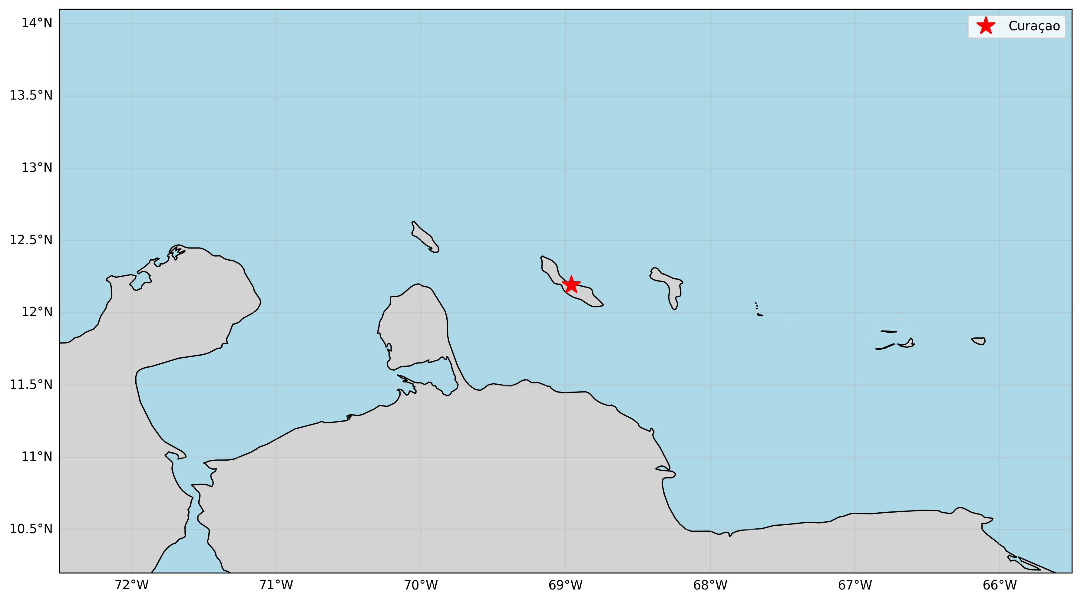
Figure: Station Location Map
The climate on these islands sets itself apart from the climate at comparable latitudes due to the proximity of the islands to the southern mainland; the influence of the mainland 60km away is large.
- Due to the influence of fresh easterly trade winds, a local upwelling zone with colder sea surface temperatures (SSTs) develops along the east-west Venezuelan coast. The resulting cold SSTs tend to suppress the development of clouds in the region.
- Furthermore, the predominant easterly trade winds generate subsiding air over the island due to ocean–land interactions at low levels along the Venezuelan coast. This subsidence also suppresses cloud development.
- During the Northern Hemisphere summer months (the high-sun season), the rainfall pattern is opposite to the typical tropical regime. Due to the sea–land breeze effect, most precipitation is suppressed during the day and tends to occur late at night or in the early morning.
The dry season runs from February through May, whereas the rainy season starts in October and ends in January. The months of July to September can be considered as transitional months. During the summer months rain showers usually occur during the early morning or early to late evening hours, which differs from the typical tropical regime. The climate has good seasonal predictability for the precipitation, which is sensitive to changes in the oceanic circulations. A Niño will suppress the main rain season (Oct-Jan) while La Niña will enhance this rain season.
Figure: Rainfall Annual Cycle
Temperatures are warm year‑round. Mean temperatures peak in September. Sea temperatures average about 27°C. They are coldest around February–March (about 25.9°C) and warmest around September–October (about 28.2°C). Skies are usually mostly clear to partly cloudy.
Figure: Temperature Annual Cycle
Tropical Cyclones
Hurricane season runs from June 1 to November 30. Activity peaks from August to October. The Dutch Leewards sit on the southern edge of the Atlantic hurricane region, making direct impacts relatively rare compared to islands farther north.
Historical Record
From 1605 through 2024, 37+ tropical cyclones have passed within 100 nautical miles of Curaçao (12.5°N, 69.0°W). This record spans over 400 years and demonstrates the islands' fortunate position on the southern fringe of the hurricane belt. No hurricane or tropical storm has ever made direct landfall on Curaçao.
Notable Historical Events:
An early recorded event was a minor hurricane that passed just south of Curaçao on September 23, 1877. It caused about US$2 million in damage, mostly near Willemstad. A nunnery was washed away, and its remains are still visible at low tide. The storm is known as Hurricane Tecla, named after a nun who survived.
Tropical Storm Joan (October 16, 1988) passed just south of the ABC Islands, causing about US$1.5 million in damage. Strong winds removed many rooftops. Rough seas damaged harbor and beach facilities. Heavy rains after the storm led to several days of flooding.
Tropical Storm Cesar (July 25, 1996) holds the record for the closest approach ever documented—passing just 1 nautical mile from the island. Despite the extremely close pass, impacts were surprisingly minimal.
21st Century Events:
- Hurricane Ivan (September 2004): Category 4 hurricane with 145 mph winds passed 65 nautical miles north—the most intense storm to pass within 100nm of Curaçao in the modern era
- Hurricane Emily (July 2005): Category 4 hurricane with 130 mph winds passed 100 nautical miles northeast
- Hurricane Felix (September 2007): Category 2 hurricane with 105 mph winds passed only 30 nautical miles north—one of the closest hurricane approaches on record
- Hurricane Matthew (September 2016): Category 1 hurricane with 80 mph winds passed 97 nautical miles north
- Tropical Storm Bonnie (June 29, 2022): The most significant direct impact in decades. Tropical Storm Warnings were issued for all ABC islands. Code Red warnings led to school closures and curfews. The storm brought 3-5 inches of rain, coastal flooding, and beach damage. This was the first time in decades that all three islands received tropical storm warnings.
- Hurricane Beryl (July 2024): The earliest Category 5 Atlantic hurricane on record (165 mph) passed well north of the islands through the Windward Islands, causing minimal impacts to the ABC Islands.
Why So Few Storms?
The ABC Islands' southern location (12-13°N) places them below the typical tracks of most Atlantic hurricanes, which tend to curve northward before reaching this latitude. Additional protective factors include:
- Cold water upwelling along the Venezuelan coast that suppresses storm development
- Due to proximity to the mainland, less humidity is available for storm development
- Atmospheric subsidence due to ocean-land interactions that inhibits convection
On average, a tropical cyclone passes within 100 nautical miles of Curaçao only once every 11 years, and direct impacts are extremely rare.
For detailed hurricane climatology and historical analysis, see our publication: Hurricanes and Tropical Storms in the Dutch Caribbean (2018).