

Latest Video
News
-

Meteo Curacao uploaded a video (7/5/2024)
Meteorological Department Curaçao
-
Meteo Curacao uploaded a video (7/1/2024)
Beryl Yuli 2024
-

-
Meteo Curacao uploaded a video (5/13/2024)
Meteorological Department Curaçao
-
Meteo Curacao uploaded a video (11/20/2023)
Boletin semanal 20 Nov te ku 26 Nov 2023
Weather Warning
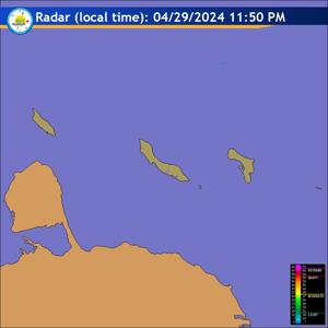
Radar
Satellite (InfraRed)

Forecast
Weather Forecast for Curaçao and surroundings valid until Monday evening 18:00
l.t., October 6, 2025.
Issued:
Sunday October 5, 2025, 17:55 l.t. (21:55 UTC).
Weather:
Skies will be partly cloudy with predominantly dry and very warm
conditions prevailing. A slight risk of an isolated early morning shower may
occur.
Forecast high will be 34ºC, and the low will be 28ºC.
Sunrise will occur at 06:25 and sunset at 18:22.
Winds:
Easterly and light to gentle; force 2 to 3 (7 to 19 km/h, 4 to 10 knots).
Occasionally reaching moderate to fresh in gusts; force 4 to 5 (20 to 39 km/h,
11 to 21 knots).
Synopsis:
A stable easterly wind regime continues to dominate the region,
maintaining predominantly dry and warm conditions. A relatively dry air mass at
the mid to upper levels inhibits convective development and limits cloud
formation. Therefore, no significant rainfall is expected during the period,
although a slight chance of early morning showers cannot be excluded due to
residual moisture and localized convergence.Surface temperatures remain elevated
and high humidity contributes to a continued feeling of warmth.
Sea conditions:
Slight to moderate with wave heights between 1 and 1.5 meters (2
to 4 feet). Swells may generate higher breaking waves along the exposed northern
areas.
Significant tropical weather systems:
None.
Special features:
None.
Outlook until Tuesday evening:
A gradual increase in cloudiness is expected with
a higher chance of brief, localized showers developing by Tuesday morning.
Forecaster:
Kasmani
The next weather forecast will be issued on Monday 05:00 l.t. (09:00 UTC).